Showing posts with label Thames Buildings. Show all posts

Tuesday, October 27, 2020

Thames (NZ): Bowen Street at the Parawai end of Thames

      Bowen Street ran from the Hape Creek in the north, to the Kauaeranga River in the south. Known now as Rolleston Street, this street was named after Sir George Bowen an early Governor of the colony. Banks Street ended at the intersection with Bowen Street, there was no need for it to run further west until the new Kauaeranga Road Bridge opened in 1924. 

Part of: Cleave's Streets Maps - of the Thames and Suburbs c1910.
Map 3577 Auckland Libraries

Photograph of Bowen Street area early 1900s.
     Imagine you are standing at the west end of Mount Pleasant, and look down over Heale, Fenton and Bowen Streets - look at the photograph below, this is the view c1900s.

View over Parawai end of Thames c1900s.

     A closer look at the left (southern) side of the photograph and the Kauaeranga Rail Bridge is open, which postdates the photo past 1898. The land beyond where Rhodes park is today is low lying and possibly covered by water in parts. Next to the river is Causley's Garden Nursery.
     The houses under the word 'Bridge' are at the southern end of Bowen Street. Note the closeness of the river - today there is the stop-bank structure. The land to the right of the houses is where the motels and garage are today, and further right the reclaimed land where Toyota car plant is sited.

     
     Moving further right (north) across the main photo, the shop is visible that for decades was at the corner of Heale and Fenton Streets. Next time you drive along Fenton and Rolleston Streets, look out for the houses that are in the photograph - with the exception of the large one in the centre (more on that soon).
     Mrs Grubb had the Fenton Street shop for many years. Out of view far right was the site of the Maori Meeting (Hotunui) house that now holds pride of place at the Auckland War Memorial Museum.

     
Now to the large house at the centre of the 1900s photo. The house was located at the corner of Fenton and Bowen (Rolleston ) Streets, on the south-east intersect. 
     There are numerous outbuildings one of which housed the wash-house,  plus there was separate servants' quarters. Built in classic villa style with the large verandah, full length windows plus several bay-windows.
     While researching the house , it was suggested that it may have belonged to the Miller family. It was occupied in the mid 1940s onwards by Mr Rutherfurd who was Mine Manager at the Sylvia Mine at Tararu.  During the home's history it was a boardinghouse and later divided into flats. The ceiling height described by a past resident as 'exceptionally high'!

     
     In the 1923 Street Directory, the property is the residence of Mr Ernest Napier Miller, Solicitor. This confirms the recollections of later owners. Mr Miller was a partner in the law firm Miller & Poulgrain. Ernest joined his father's firm in 1900, it was then known as Miller & Son. Ernest's brother Selwyn lied in the same block on the corner of Banks and Heale Street.     
     Mr E N Miller was Mayor of Thames 1919 to 1923, both he and his wife were active members of the community. During the 1918 influenza epidemic, Mrs Miller was in-charge of the convalescent hospital in Queen Street. Mr Miller also helped staff Thames Hospital during the epidemic.

THAMES STAR, ISSUE 13836, 30 NOVEMBER 1918

THAMES STAR, VOLUME LII, ISSUE 13854, 14 NOVEMBER 1918

What became of the house at the corner of Rolleston and Fenton Street?
     The good news is that while it did not remain in Thames, it was sold in 1996, and moved north to the Wellsford area. 

Hauraki Herald 23 March 1996

Mr Ernest James Napier Miller's Death Notice & Obituary. Thames Star 15 Oct 1947


Friday, June 5, 2020

Thames (NZ): Asphalt arrives at the Thames Goldfield

Excitement at The Thames 12 October 1877, the first asphalt footpath was completed! Whats the big deal you may ask, and was it really the first? (Note variant spelling in the newspapers as 'asphalte')

THAMES ADVERTISER, 22 OCTOBER 1877

The first footpaths at Shortland Town and Grahamstown
   Mathias Whitehead came to Shortland Town in 1868 and described the state of the roads and footpaths at the time of the 1917 reunion. Whitehead recalled the town as the "City" of Board of Works [sic], "when a substantial wooden footpath was laid down" because most walkways were impassable in the early years on the goldfield.

 
 Left: Whitehead's report on the state of the footpaths. Thames Star 1 August 1917.  Right: 'Boardwalks' surrounded shops at the Thames Museum during 'Heritage Rescue' filming 2015. These have since been removed.

Above: This is the area of Shortland Town that Mathias Whitehead was talking about. Spot the wooden boxing used to separate road from footpath and to act as a drain. In some cases this was enough to keep the footpath in good condition, as the shop owners could afford it, a wooden board walk was added.

      Any alterations to the footpaths had to be approved by the local Highway Board. In April 1872, Mr Ehrenfried applied to the Waiotahi District Highway Board to build a wooden footpath in front of the Grahamstown Hotel.
      While initially a success, within a few years the wooden footpaths began to deteriorate. The cause varied from children deliberately vandalising the footpaths to mobs of cattle being driven through the town straying on them. One of the most significant was water damage from floods and high tides. Hence they soon became unsafe and a danger to pedestrians.

The Asphalt solution!
     There are reports in the newspapers around New Zealand in the 1860s about footpath construction and various methods of compressing rock, to the use of tar or asphalt.
     There are no mentions of 'asphalt' in the Thames Guardian newspaper 1871-1872.
From 1874 the Thames Star (Evening Star) and Thames Advertiser are online at Paperspast, below is a summary of the development and use of asphalt footpaths:
  •  1874 24 Sept Thames Advertiser: The Union Bank of Australia (corner Queen & Albert Streets) were building a new brick premises and planned to have an asphalt footpath.
  • 1876 13 March Thames Star: The Borough asphalters were busy outside the Academy of Music and Pacific Hotel in Brown Street.
Thames Star 13 March 1876.
  • 1877 12 October Thames Advertiser: The report stated the first asphalte footpath at the Thames was completed in front of the Bank of New Zealand in Brown Street.
  • 1877 26 June Thames Star: The Thames Borough Council suggested that the repairs to the footpath outside the Theatre Royal Hotel in Williamson Street, be constructed in asphalt.
  • 1878 16 January Thames Star: It was not just footpaths that were being made in asphalt, the floor of the new fire engine shed at Shortland was being laid with this product.
  • 1878 28 January Thames Star:  News that the Queens Hotel (corner of Albert & Queen Streets), and the Pacific Hotel (corner Brown & Albert Street) were both planning to put down asphalt footpaths outside their premises. In one month March-April 258 yards of asphalt were laid outside the hotel.
  • 1878 6 April Thames Star: It was noted by a writer named 'Perambulator' that it was pleasing to see townsfolk showing faith in the town by making upgrades such as laying on water and gas, plus laying down asphalt footpaths.
  • 1878 9 April Thames Star: The new footpaths were taking a bit of getting used to, painters were warned about the use of ladders in the newly laid asphalt paths as they were prone to leaving holes especially on hot days. 
  • 1878 19 April Thames Star: All the asphalt work around the town, meant that the Council was busy trying to procure further supplies of stone or gravel - Tenders were called for 200 cubic yards.
  • 1878 31 May Thames Advertiser: Problems were encountered with the new method of laying footpaths, the join between old and new was prone to causing problems. "An instance occurred last night. The respected incumbent of St George's was escorting one of the members of his choir home, when opposite the Queen's Hotel he was forced to his knees, and compelled to maintain a recumbent attitude for a few seconds, through the unevenness of the new path where it joins old."
What were the costs of the footpaths?
    As at March 1878 the average cost of footpaths per running foot was: Asphalt 3s 4d; common filling with water tables 2s 4d; common filling without water tables 1s 6d. A report to the local Council recommended that water tables and a footpath be completed the length of Pollen Street from Shortland to Grahamstown.  The cost 937 Pounds 8 shillings. For a 3 foot wide asphalt path laid along side the tables the total cost would be 1406 Pounds 16 shillings.
     As the months passed, more side streets were planned to have footpath upgrades. The costs were often under debate, Mr Soury for instance claimed 12 October 1878, that he could lay the new asphalt footpaths at a greatly reduced rate.
     The local cricket club saved some money by getting a loan of the asphalt roller to roll the cricket green for the new season. (Thames Star 27 August 1880)
     Ongoing costs ensued over the following years. Topdressing of the original footpath was needed as part of the maintenance routine, plus repairs to sections of the path due usually to sinking and subsidence.

Initially it was exciting to get a date for the first asphalt footpath at the Thames - 12 October 1877. However there appears to have been without question several sections of footpath laid during 1874 to 1876, along with the use of asphalt for floors in some premises. In the following decades, asphalt tennis courts make the headlines on numerous occasions! Regardless, the use of the asphalt process / material was a great improvement over the initial paths tread by the first settlers on the Thames Goldfield.

Above: Boardwalk sections can be seen top right outside the St George's Hall at the northern end of Pollen Street, along with boardwalk crossings to several hotels and businesses on the eastern side of the street.

Above: early 1900s view of Bank of New Zealand (centre right), the reported area where the first asphalt footpath was laid in 1877.
Below: Then & Now. The Pacific (left out of view) & Wharf Hotel on the left c1880, corner Albert and Brown Streets. The area where asphalt was reported to be laid in 1876. 
 

Sunday, May 17, 2020

Thames (NZ): Grahamstown a second look in colour

Industrial Grahamstown & beyond:

Grahamstown
Te Papa Tongarewa
Do you have a favourite view of the Grahamstown and Moanataiari area during the goldrush? It may depend on whether you are looking for examples of housing, trying to identify shops or mining activities or some other landmark?

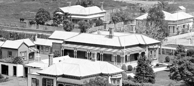
One of the best examples is this image taken by Daniel Mundy c1871 from the vicinity of the Eureka / Shotover Road, south of  present day Kuranui Bay. (photo right)

You can almost smell the smoke and hear the noise of the mining operations dotted along the narrow section of land between hill and sea - unrecognisable today following decades of reclamation.

Grahamstown through colourised lens:

Would colour make a difference to your perception of the view?

Thanks to Tom B for labelling some of the landmarks. To help get your bearings, the Moanataiari Battery (in the centre) would present day be located on the intersection of Ferguson Drive, SH 25 and Dickson Street.

Colourised View of Grahamstown courtesy of MyHeritage.

From left to right (east to west) the following landmarks are marked: Golden Crown Mine (behind Tookey's Shaft), Tookey's Mine, Caledonian Battery, Souters Battery, Kuranui Battery, United Pumping Association / Big Pump, Smale's Folley, Moanataiari Battery, Holdship's Wharf, Grahamstown Tramway and the Kuranui Hotel.


Fascinating to see the detail of the "pond" in the photograph. Initially in the original format I thought it was tailings or waste from one of the industrial sites in the area. The colourised view however shows incredible details of a sandbag type construction, was it therefore more likely a water reserve for public or business use? (see image crop below)


Now to the study of a miner's house, their pride and enjoy and a place to escape the madness of the goldfield. A small cottage, probably divided into two rooms, one living one sleeping, plus a large covered front veranda. The property is fenced with a front and side gate. A large chimney providing a fire for cooking and warmth. The window on the side, appears to be boarded rather than glassed as those of the neighbouring houses.

Washing hangs on a line, plus larger items are draped over the northern fence. Where is the outhouse? A pick or shovel lies at the back of the house by the chimney, alongside a panning dish.

The house is in danger! A rock slide threatens to engulf the backyard and the house, it has already broken part of the back fence.


Remember to stop and take a second look, find something new to focus on 
and piece together possible history scenarios.

Background:

Caledonian Mine: Started in 1867, and experienced a short bonanza. Over the years, expanded under various ownership groups. Total output 55,529 tons of quartz, which yielded 277,166 oz. bullion valued at 764,676 Pounds. (Downey, page 81)

Golden Crown Mine: First successful find in 1868, then only achieved success for the 'usual' short period. Expanded and later taken over by the Caledonian Company and finally the Waiotahi Company. Total output 32,483 tons of quartz, which yielded 91,760 oz. bullion valued at 248,896 Pounds. (Downey, page 274)

 
Thames Lions Club Heritage signs for the Caledonian and Golden Crown Mines.


Grahamstown Tramway: A tramway that ran from near the wharf at Albert Street along the foreshore to Tararu. thousands used this mode of transport, it was a surprise to many that this was not extended to Shortland Town. Tramways were essential for mining companies to transport their ore for processing and disposing.

Holdship's Wharf: Holdship's Mill was located at the corner of Beach Road and Cochrane Street. Previously the site of an old Maori pa, and where Mr R B Smith opened a store known as the “Pah Store”. The Holdship Timber Company owned the wharf.

Kuranui Battery: When the battery was sold in 1916 the contents included 20 head of stampers, 10 berdans, two pelton wheels and an assay room.

Kuranui Hotel: Located on the foreshore, the hotel opened March 1868. In January 1875, the hotel was placed for mortgagee sale, described as being on Land parcel 1132, Moanataiari Number One, Tookey’s Flat. Land size approximately 28 perches. On 27th August 1876, a destructive fire occurred which destroyed the Kuranui Hotel and several adjoining properties.

Smale's Building aka Smale's Folley:  A long corrugated iron building extending from Pollen to Queen Street, the site of the present Post Office. Built to provide accommodation for miners, but proved unpopular as a boarding house option. Temperance meetings were held at the building, by 1871 often called Temperance Hall.

Tookey's Mine: Daniel Tookey was an early miner on the goldfield, his claim located near the mouth of the Moanataiari Stream. Total output 9,401 tons of quartz, which yielded 16,049 oz. bullion valued at 41,275 Pounds. (Downey, page 282)

United Pumping Association / Big Pump: Constructed in 1872, and replaced around 1895 by the Thames-Hauraki Pumping Association's plant in Bella Street. Pumps were vital on the Thames goldfield to drain the water out of mine shafts. (Wilton, 2012)

References:
Gold-Mines of the Hauraki District, J F Downey. Cadsonbury Publications Reprint 2002.
The Big Pump Site Revisited in 2012, David Wilton. The Treasury Journal.

LIST OF KNOWN BATTERIES
Battery Name/s

Location
Albion Battery Grahamstown
Alburnia Battery Moanataiari
Anchor Battery Thames
Arrundell Syndicate Battery Karaka
Atlas Battery Karaka
Aurora Battery Tararu
Australasian Battery Waiotahi
Ballarat And Clunes Battery Tararu Creek
Bedford Battery Hape Creek
Berdan Battery Thames
Berrys Plant Tararu
Bleazard's Battery (previously Pactolus) Thames
Break O'Day Battery Thames
Brighton Battery Waiotahi 
Brissenden And Co Battery Thames
Brown And Campbells Battery Tararu
Bull's Battery Karaka Creek
Caledonian Battery Thames
Cambria Thames
Captain Ninnis Battery Thames
Carfrae, Stewart and Russell Battery Thames
Central Italy Battery Moanataiari
City Of London Battery Grahamstown
Clarkson's Battery Shellback
Cornstalk Battery Waiotahi
Coulabah Battery Karaka
Criterion Battery Waiotahi
Crown Princess Battery Grahamstown
Dart Battery Thames
Dayspring Battery Thames
De Hirsch Battery Waiotahi
Deep Lead Battery Kurunui
Eaton and Dewolf's Battery Thames
Eclipse Battery Tararu
Eglington Battery Waiotahi
Ethel Reefs Battery Hape
Fairmile Shortland
Fame and Fortune Battery Thames
Farmer's Battery Thames
Fearnaught Battery Thames
Flora Mcdonald Battery Tararu
Gibbon's Battery Thames
Golden Calf Battery Moanataiari
Golden Crown Battery Grahamstown
Goodall's Battery Moanataiari
Great Expectations Mill Thames Goldfields
Greenville's Battery Hape Creek
Greenway's Battery Hape Creek
Grove Battery Hape
Halcyon Battery Karaka Creek
Hape Battery Hape
Hauraki Battery Waiotahi
Herald Battery Thames
Hokianga Battery Karaka
Holdship And Co Battery Karaka
Homeward Bound Battery Kuranui 
Imperial Crown Battery Grahamstown
Judd Battery Karaka
Kauaeranga Battery Karaka
Kuranui Battery Grahamstown
Ladybird Battery Thames
Launceston Battery Moanataiari Creek
Little And Good Battery Karaka
Little Lizzie Battery Karaka
Lord Nelson Battery Hape Creek
Lucky Hit Battery Karaka Creek
Manning Battery Hape
Manukau Battery Grahamstown
Massey's Battery Thames
May Queen Thames
McIsaac's Battery Karaka
Middle Star Battery Moanataiari
Missouri Battery Tararu
Moanataiari Battery Moanataiari
Morning Star Battery Moanataiari
Nonpareil Battery Moanataiari
Onehunga Battery Karaka Creek
Pactolus Battery (later Bleazards) Thames
Pahau Battery Grahamstown
Partington's Battery Tararu
Perry Battery Karaka
Piako Battery Grahamstown
Pioneer Battery Moanataiari
Planet Battery Karaka
Price Brothers Battery Grahamstown
Prince Alfred Battery (aka Goodall's) Thames
Prince Imperial Battery Grahamstown
Punga Flat Battery Punga Flat
Pyrites Company Battery Grahamstown
Queen Of Beauty Battery Grahamstown
Queen Of May Battery Waiokaraka
Raithby And Muir Battery Hape
Russell's Battery Tararu Creek
S H Smith's Battery Thames
Savery And Co Tararu
Saw Mill Hape Creek Battery Shortland
Sawyer's Battery Waiotahi
Scottish Chief Upper Tararu
Shotover Battery Kurunui
Sir William Wallace Battery Karaka
Souter's Battery Waiotahi
Spencer's Battery Thames
Sprague Battery Thames
Star of Polynesia Battery Thames
Star Of The South Battery Moanataiari
Sunnybank Battery Tararu
Sylvia Battery Tararu
Tararu Battery (Campbell, Brown & Co) Tararu
Test & Specimen Battery Karaka
Thames Battery Moanataiari Creek
Thames Foreshore Plant Thames
Thomas Battery Hape
Thwaites And Co Battery Grahamstown
Tookey's Battery Tookey's Flat
Tramway Battery Moanataiari Creek
Una Battery Karaka Creek
United Pumping Association Battery Thames
United Service Battery Moanataiari
Vickery's Battery Karaka
Victoria Battery Moanataiari
Vulcan Battery Upper Tararu
Waiotahi Battery Waiotahi
Waitemata Battery Moanataiari
Westons Battery Waiotahi
Whau Battery Moanataiari
Wild Missouri Battery Tararu

Tuesday, May 5, 2020

Thames (NZ): The Walkabout continued!

This morning was the day for a circuit around Thames South School and St Francis School.

What a delight to spot this beautiful pavement art outside St Francis School's Baillie Street entrance. An example of what you miss in a car, and demonstrates that walking definitely has its positives! The painted mural is large and detailed, as you can tell from the small snip below.

Pavement mural, Baillie Street Thames

This area of Baillie Street and Mackay Street always reminds be of the early photographs taken in this block by the American Photographic Company. The Hape Creek meandered in a less ordered fashion than today, but a footbridge still goes from Baillie to Clarence Street.

Then & Now: c1868 & 2020, Looking towards the Mackay and Grey Street intersect.
Source for photo on left: View of the Hape Creek. From the album: Views of the Thames Gold Fields; American Photographic Company. Te Papa Tongarewa.

Turn around in Baillie Street and look north towards the Una / Karaka Hill and see past and present. The present day footbridge is in the right photo by the power pole.

 
Then & Now: c1868 & 2020, Looking towards the Una Hill from Baillie Street.
Source for photo on left: View of the Hape Creek & Ranges. From the album: Views of the Thames Gold Fields; American Photographic Company. Te Papa Tongarewa.

At last, Thames South School is reached! While school is out, this photo from photographer Daniel Manders allows us to view the scene in the 1880s. When no school yet existed on the site. The building on the right is the House of Hotunui at the corner of Bowen and Fenton Street.

 
Then & Now: 1880s & 2020, Looking towards the Thames South school site Grey Street.
Source: Left Photo: View from Shortland, looking towards Parawai. Beere, Daniel Manders, 1833-1909 :Negatives of New Zealand and Australia. Ref: 1/2-096137-G. Alexander Turnbull Library, Wellington, New Zealand. http://natlib.govt.nz/records/23047558  Right: Google maps 5 5 2020.

The full colourised version of Daniel Beere's photograph courtesy of MyHeritage Colour.

Monday, April 13, 2020

Thames (NZ): Karaka Road homes 1868 / 1870s - a Second Look


Description: Looking over Karaka Creek, Thames, showing Bulls Battery (centre foreground); St Georges Church (right rear); miners' tents, raupo huts (left foregound and centre), privies, and cottages.
Auckland Libraries Heritage Collections 4-RIC134


Description: Shortland, view from Irishtown over Karaka Creek to Karaka Road. Block 27 (up to the right), and over to Sandes Street and Edward Street. Lower right centre is Rolleston Street and Shortland Town in the distance. George Bulls Battery front right.
Auckland Libraries Heritage Collections 536-Album-285-12-1

Take a Second look! Do you sometimes look at an old photograph of Thames, and mentally just say, "Oh yes, I have seen that before - nothing new to see!?"

Stop, have another look at the two photographs above from Auckland Libraries Sir George Grey Collection. While the angles are slightly different, you can see homes of varying construction material. There are tents (large and small), thatched roof huts, timber shops and houses, plus a mining battery in the lower view. Even a tramway track from up the Karaka / Una Hill.

Within a few months you can see how buildings were constructed to line Karaka Road.

If you need to get your bearings, here is a named photograph.


What fascinated me most when I had a second look, was the Thames' first pole houses!!! No time to dig out the site and get a level plot of land...just build and have the front half on piles resembling stilts! Also look for the houses and see if any changed over a couple of years in the early 1870s.


 The fenced sections on the south of Karaka Road make it easy to find the houses and what development has taken place. The two houses on the far right proudly standing on their 'stilt' piles. Did you notice that there is a front door? but no steps. Definitely have to use the back door until there is money for a front verandah and steps. Can you make a judgement on the weather in the photo far right? Check out the washing, its blowing and flapping on the long lines, no doubt supported by a good old ti-tree prop.

Lastly, to finish our second look, check out the businesses in Karaka Road. The two-storied one (with the rear entrance visible is almost definitely a hotel. Several up this road had accommodation on the second story, which was actually only tall enough to crawl in for most patrons.

Part of Auckland Libraries Heritage Collections 536-Album-285-12-1