Showing posts with label Thames Reclamations. Show all posts

Tuesday, October 27, 2020

Thames (NZ): Bowen Street at the Parawai end of Thames

      Bowen Street ran from the Hape Creek in the north, to the Kauaeranga River in the south. Known now as Rolleston Street, this street was named after Sir George Bowen an early Governor of the colony. Banks Street ended at the intersection with Bowen Street, there was no need for it to run further west until the new Kauaeranga Road Bridge opened in 1924. 

Part of: Cleave's Streets Maps - of the Thames and Suburbs c1910.
Map 3577 Auckland Libraries

Photograph of Bowen Street area early 1900s.
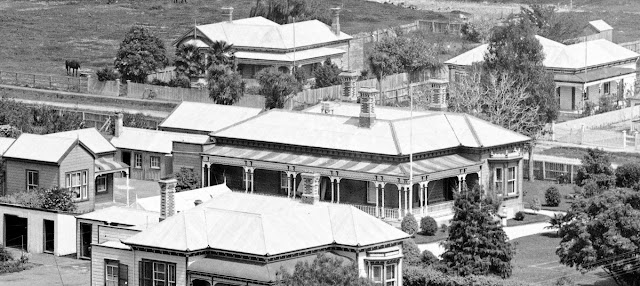
     Imagine you are standing at the west end of Mount Pleasant, and look down over Heale, Fenton and Bowen Streets - look at the photograph below, this is the view c1900s.

View over Parawai end of Thames c1900s.

     A closer look at the left (southern) side of the photograph and the Kauaeranga Rail Bridge is open, which postdates the photo past 1898. The land beyond where Rhodes park is today is low lying and possibly covered by water in parts. Next to the river is Causley's Garden Nursery.
     The houses under the word 'Bridge' are at the southern end of Bowen Street. Note the closeness of the river - today there is the stop-bank structure. The land to the right of the houses is where the motels and garage are today, and further right the reclaimed land where Toyota car plant is sited.

     
     Moving further right (north) across the main photo, the shop is visible that for decades was at the corner of Heale and Fenton Streets. Next time you drive along Fenton and Rolleston Streets, look out for the houses that are in the photograph - with the exception of the large one in the centre (more on that soon).
     Mrs Grubb had the Fenton Street shop for many years. Out of view far right was the site of the Maori Meeting (Hotunui) house that now holds pride of place at the Auckland War Memorial Museum.

     
Now to the large house at the centre of the 1900s photo. The house was located at the corner of Fenton and Bowen (Rolleston ) Streets, on the south-east intersect. 
     There are numerous outbuildings one of which housed the wash-house,  plus there was separate servants' quarters. Built in classic villa style with the large verandah, full length windows plus several bay-windows.
     While researching the house , it was suggested that it may have belonged to the Miller family. It was occupied in the mid 1940s onwards by Mr Rutherfurd who was Mine Manager at the Sylvia Mine at Tararu.  During the home's history it was a boardinghouse and later divided into flats. The ceiling height described by a past resident as 'exceptionally high'!

     
     In the 1923 Street Directory, the property is the residence of Mr Ernest Napier Miller, Solicitor. This confirms the recollections of later owners. Mr Miller was a partner in the law firm Miller & Poulgrain. Ernest joined his father's firm in 1900, it was then known as Miller & Son. Ernest's brother Selwyn lied in the same block on the corner of Banks and Heale Street.     
     Mr E N Miller was Mayor of Thames 1919 to 1923, both he and his wife were active members of the community. During the 1918 influenza epidemic, Mrs Miller was in-charge of the convalescent hospital in Queen Street. Mr Miller also helped staff Thames Hospital during the epidemic.

THAMES STAR, ISSUE 13836, 30 NOVEMBER 1918

THAMES STAR, VOLUME LII, ISSUE 13854, 14 NOVEMBER 1918

What became of the house at the corner of Rolleston and Fenton Street?
     The good news is that while it did not remain in Thames, it was sold in 1996, and moved north to the Wellsford area. 

Hauraki Herald 23 March 1996

Mr Ernest James Napier Miller's Death Notice & Obituary. Thames Star 15 Oct 1947


Tuesday, September 8, 2020

Thames (NZ): Then & Now Beach Road

Introduction

      Beach Road, at the Grahamstown end of Thames - a quiet spot, with a narrow road, that has metal parking areas. 


     The south side of Victoria Park is on the western side, along with the Petanque area and Croquet Club. Travel further north and there is an access to the walkway that loops around the coast to the old Burke Street Wharf. On the eastern side you start at Albert Street, to Williamson Street, past A & G Price Foundry to the Burke Street intersect - then the road becomes Tararu Road.

 
Then & Now: 1900s & 2018 Corner of Beach Road and Albert Street.

Beach Road History (From Streets of Thames)
     "Named after the location, originally adjacent to the beach before reclamation was carried out.  
     On the 1868 map there is no Beach Road, although there is an unnamed road (where Brown street meets Cochrane Street and along to Pahau Street). 
     The 1910s Cleave’s map records Beach Road extending to Mary Street as well as a portion of road from Albert Street to Coromandel Street intersect. The road length was changed in 1938, today Beach Road only runs from Burke Street (north) to Albert Street (south)."

1868 map - Beach Road does not exist. The red line marks the location of Beach Road today.
Residents and business along the foreshore gave their address as The Beach.

1910s Map - the 'x's mark the two portions of Beach Road. Coromandel intersect to Albert Street intersect; and Cochrane to Mary Street intersects.

Collage View of Victoria Park south, on Beach Road.
In the 1900s, the view was unobstructed,
 and you could watch the ships arriving at the Burke Street Wharf.

Residents of Beach Road 1870 and 1923
     In the Thames Directory 1870, the road still does not formally exist, however a large group of businesses and residents record their address as "Beach". They included: Joseph Bargrove's Ladies' School, H C Lawlor, Joseph Faltt (carpenter), John McConnell, Charles Toft (store dealer), James Buchanan (stone-cutter), John Taylor (Bay View Timber Yard), William Anderson (architect), John Gwynneth, R N Smith (store dealer), M Rae ( Cornwallis Saw Mills, Miss Shepherd (actress), Richard Dodd's Boarding-house, Henry Phillips (boat builder), Holdship's Timber Yard, Wesleyan Chapel, Thomas Sharp (engineer), S Smale (legal manager), Thomas Keven's Boarding-house, John McColloch, Frederick Smith, Richard Richards, Marine Fmaily Hotel, Native Office (E Puckey), C F Quint, M Browne (coal merchant), Alexander Unthank (coal merchant), B Jones (actor) and George McAnnalley (telegraph linesman).

      In the Cleave's Street Directory 1923 the names recorded in Beach Road are: 
Right side from Haven Street: Thames Railway Station, John Arthur (stationmaster) ... nothing further is recorded until Mary Streets.
     On the left hand side from Haven Street: A & G Price Bulk Store, William Wells (labourer), Charles Fleming (moulder), John Coutts (boilermaker), Arthur Henderson (fitter). 
Burke Street intersect. A & G Price Ltd.  Abraham Street intersect. Rawiri Pearson (carpenter), Wm H Lucas (JP), Mrs Dunbar (Gwendon Boardinghouse), Thomas Dunbar (hairdresser - private residence), John Milner (boilermaker), Thomas McLeay (tailor), 
John Galloway (grocer). 
Williamson Street intersect. John Salmon (SM), Reg Williams (Manager A & G Price), James Parkinson (jeweller), Alf Lomas (carter), Park Hotel (back entrance). 
Albert Street intersects.  Cochrane Street intersects.
Richard Dovell (carrier), Wm Milne (foundry hand), Jas Frogley (store manager), Mrs Margaret Bayldon, Arthur Batchelor (machinist), John Judd (pattern maker). 
Amy Street intersects. Mrs Elizabeth Heard, Miss Alice Wishart, John Wells (labourer), William Skelley (labourer), Duncan McKenzie (bush contractor).
Walters Street intersects.  Mary Streets intersect.


Closing Comments
   Once a thriving street, Beach Road was full of businesses and residents. A popular place to live for those who worked at the foundry as evident in the Cleaves 1923 Street Directory. A busy and noisy place, close to A & G Price, and an area that once boasted a railway track, in the days of the trains being made and refurbished at the nearby foundry.

Take the Challenge
    Wander the streets - stop and imagine how it would have looked one hundred years ago.

CLICK HERE for further Street 'Then & Now" photos.

Sunday, May 17, 2020

Thames (NZ): Grahamstown a second look in colour

Industrial Grahamstown & beyond:

Grahamstown
Te Papa Tongarewa
Do you have a favourite view of the Grahamstown and Moanataiari area during the goldrush? It may depend on whether you are looking for examples of housing, trying to identify shops or mining activities or some other landmark?

One of the best examples is this image taken by Daniel Mundy c1871 from the vicinity of the Eureka / Shotover Road, south of  present day Kuranui Bay. (photo right)

You can almost smell the smoke and hear the noise of the mining operations dotted along the narrow section of land between hill and sea - unrecognisable today following decades of reclamation.

Grahamstown through colourised lens:

Would colour make a difference to your perception of the view?

Thanks to Tom B for labelling some of the landmarks. To help get your bearings, the Moanataiari Battery (in the centre) would present day be located on the intersection of Ferguson Drive, SH 25 and Dickson Street.

Colourised View of Grahamstown courtesy of MyHeritage.

From left to right (east to west) the following landmarks are marked: Golden Crown Mine (behind Tookey's Shaft), Tookey's Mine, Caledonian Battery, Souters Battery, Kuranui Battery, United Pumping Association / Big Pump, Smale's Folley, Moanataiari Battery, Holdship's Wharf, Grahamstown Tramway and the Kuranui Hotel.


Fascinating to see the detail of the "pond" in the photograph. Initially in the original format I thought it was tailings or waste from one of the industrial sites in the area. The colourised view however shows incredible details of a sandbag type construction, was it therefore more likely a water reserve for public or business use? (see image crop below)


Now to the study of a miner's house, their pride and enjoy and a place to escape the madness of the goldfield. A small cottage, probably divided into two rooms, one living one sleeping, plus a large covered front veranda. The property is fenced with a front and side gate. A large chimney providing a fire for cooking and warmth. The window on the side, appears to be boarded rather than glassed as those of the neighbouring houses.

Washing hangs on a line, plus larger items are draped over the northern fence. Where is the outhouse? A pick or shovel lies at the back of the house by the chimney, alongside a panning dish.

The house is in danger! A rock slide threatens to engulf the backyard and the house, it has already broken part of the back fence.


Remember to stop and take a second look, find something new to focus on 
and piece together possible history scenarios.

Background:

Caledonian Mine: Started in 1867, and experienced a short bonanza. Over the years, expanded under various ownership groups. Total output 55,529 tons of quartz, which yielded 277,166 oz. bullion valued at 764,676 Pounds. (Downey, page 81)

Golden Crown Mine: First successful find in 1868, then only achieved success for the 'usual' short period. Expanded and later taken over by the Caledonian Company and finally the Waiotahi Company. Total output 32,483 tons of quartz, which yielded 91,760 oz. bullion valued at 248,896 Pounds. (Downey, page 274)

 
Thames Lions Club Heritage signs for the Caledonian and Golden Crown Mines.


Grahamstown Tramway: A tramway that ran from near the wharf at Albert Street along the foreshore to Tararu. thousands used this mode of transport, it was a surprise to many that this was not extended to Shortland Town. Tramways were essential for mining companies to transport their ore for processing and disposing.

Holdship's Wharf: Holdship's Mill was located at the corner of Beach Road and Cochrane Street. Previously the site of an old Maori pa, and where Mr R B Smith opened a store known as the “Pah Store”. The Holdship Timber Company owned the wharf.

Kuranui Battery: When the battery was sold in 1916 the contents included 20 head of stampers, 10 berdans, two pelton wheels and an assay room.

Kuranui Hotel: Located on the foreshore, the hotel opened March 1868. In January 1875, the hotel was placed for mortgagee sale, described as being on Land parcel 1132, Moanataiari Number One, Tookey’s Flat. Land size approximately 28 perches. On 27th August 1876, a destructive fire occurred which destroyed the Kuranui Hotel and several adjoining properties.

Smale's Building aka Smale's Folley:  A long corrugated iron building extending from Pollen to Queen Street, the site of the present Post Office. Built to provide accommodation for miners, but proved unpopular as a boarding house option. Temperance meetings were held at the building, by 1871 often called Temperance Hall.

Tookey's Mine: Daniel Tookey was an early miner on the goldfield, his claim located near the mouth of the Moanataiari Stream. Total output 9,401 tons of quartz, which yielded 16,049 oz. bullion valued at 41,275 Pounds. (Downey, page 282)

United Pumping Association / Big Pump: Constructed in 1872, and replaced around 1895 by the Thames-Hauraki Pumping Association's plant in Bella Street. Pumps were vital on the Thames goldfield to drain the water out of mine shafts. (Wilton, 2012)

References:
Gold-Mines of the Hauraki District, J F Downey. Cadsonbury Publications Reprint 2002.
The Big Pump Site Revisited in 2012, David Wilton. The Treasury Journal.

LIST OF KNOWN BATTERIES
Battery Name/s

Location
Albion Battery Grahamstown
Alburnia Battery Moanataiari
Anchor Battery Thames
Arrundell Syndicate Battery Karaka
Atlas Battery Karaka
Aurora Battery Tararu
Australasian Battery Waiotahi
Ballarat And Clunes Battery Tararu Creek
Bedford Battery Hape Creek
Berdan Battery Thames
Berrys Plant Tararu
Bleazard's Battery (previously Pactolus) Thames
Break O'Day Battery Thames
Brighton Battery Waiotahi 
Brissenden And Co Battery Thames
Brown And Campbells Battery Tararu
Bull's Battery Karaka Creek
Caledonian Battery Thames
Cambria Thames
Captain Ninnis Battery Thames
Carfrae, Stewart and Russell Battery Thames
Central Italy Battery Moanataiari
City Of London Battery Grahamstown
Clarkson's Battery Shellback
Cornstalk Battery Waiotahi
Coulabah Battery Karaka
Criterion Battery Waiotahi
Crown Princess Battery Grahamstown
Dart Battery Thames
Dayspring Battery Thames
De Hirsch Battery Waiotahi
Deep Lead Battery Kurunui
Eaton and Dewolf's Battery Thames
Eclipse Battery Tararu
Eglington Battery Waiotahi
Ethel Reefs Battery Hape
Fairmile Shortland
Fame and Fortune Battery Thames
Farmer's Battery Thames
Fearnaught Battery Thames
Flora Mcdonald Battery Tararu
Gibbon's Battery Thames
Golden Calf Battery Moanataiari
Golden Crown Battery Grahamstown
Goodall's Battery Moanataiari
Great Expectations Mill Thames Goldfields
Greenville's Battery Hape Creek
Greenway's Battery Hape Creek
Grove Battery Hape
Halcyon Battery Karaka Creek
Hape Battery Hape
Hauraki Battery Waiotahi
Herald Battery Thames
Hokianga Battery Karaka
Holdship And Co Battery Karaka
Homeward Bound Battery Kuranui 
Imperial Crown Battery Grahamstown
Judd Battery Karaka
Kauaeranga Battery Karaka
Kuranui Battery Grahamstown
Ladybird Battery Thames
Launceston Battery Moanataiari Creek
Little And Good Battery Karaka
Little Lizzie Battery Karaka
Lord Nelson Battery Hape Creek
Lucky Hit Battery Karaka Creek
Manning Battery Hape
Manukau Battery Grahamstown
Massey's Battery Thames
May Queen Thames
McIsaac's Battery Karaka
Middle Star Battery Moanataiari
Missouri Battery Tararu
Moanataiari Battery Moanataiari
Morning Star Battery Moanataiari
Nonpareil Battery Moanataiari
Onehunga Battery Karaka Creek
Pactolus Battery (later Bleazards) Thames
Pahau Battery Grahamstown
Partington's Battery Tararu
Perry Battery Karaka
Piako Battery Grahamstown
Pioneer Battery Moanataiari
Planet Battery Karaka
Price Brothers Battery Grahamstown
Prince Alfred Battery (aka Goodall's) Thames
Prince Imperial Battery Grahamstown
Punga Flat Battery Punga Flat
Pyrites Company Battery Grahamstown
Queen Of Beauty Battery Grahamstown
Queen Of May Battery Waiokaraka
Raithby And Muir Battery Hape
Russell's Battery Tararu Creek
S H Smith's Battery Thames
Savery And Co Tararu
Saw Mill Hape Creek Battery Shortland
Sawyer's Battery Waiotahi
Scottish Chief Upper Tararu
Shotover Battery Kurunui
Sir William Wallace Battery Karaka
Souter's Battery Waiotahi
Spencer's Battery Thames
Sprague Battery Thames
Star of Polynesia Battery Thames
Star Of The South Battery Moanataiari
Sunnybank Battery Tararu
Sylvia Battery Tararu
Tararu Battery (Campbell, Brown & Co) Tararu
Test & Specimen Battery Karaka
Thames Battery Moanataiari Creek
Thames Foreshore Plant Thames
Thomas Battery Hape
Thwaites And Co Battery Grahamstown
Tookey's Battery Tookey's Flat
Tramway Battery Moanataiari Creek
Una Battery Karaka Creek
United Pumping Association Battery Thames
United Service Battery Moanataiari
Vickery's Battery Karaka
Victoria Battery Moanataiari
Vulcan Battery Upper Tararu
Waiotahi Battery Waiotahi
Waitemata Battery Moanataiari
Westons Battery Waiotahi
Whau Battery Moanataiari
Wild Missouri Battery Tararu

Thursday, May 2, 2019

Thames (NZ): Thames Photograph 1890s

Thanks to Tom for finding a 'new' photograph of The Thames c1890. Yes, there is a new source available full of lots of treasures for the Thames researcher.

The image is available at a newly launched site by Auckland Libraries that is a portal for their Heritage Collections Online - KURA.

There are Photographs, Heritage Maps, Manuscripts, Auckland People and Events, Passengers & Vessels, Cemetery Records, Rare Books, Journals, Index Cards,  Local History and Oral History.

View south towards old Grahamstown - down Owen Street (centre).
Auckland Libraries Heritage Collections 1596-501

Closer look along Owen Street towards Brown Street.

There is so much to see in this photograph. In the crop above, the Pacific Hotel at the corner of Brown and Albert Streets can be seen. Note how the sea came literally up to the shops on the west side of Brown Street, and a reclamation had taken place for the Thames Railway line. The enclosed 'lagoon' is now the site of the Victoria Park. Of particular interest are the tall trees all over the town. Who had planted them and when?

Background on the Trees.
In January 1879, it was reported that willows and poplars had been planted around the Thames Borough streets. It was reported that townsfolk were grateful for the shade the new trees were providing, but alas came the troublesome news that boys and goats were damaging the trees! The goats were eating the bark, while butcher boys were breaking off branches to use as 'switches'.

By April 1881, the editorial noted Mary Street presented a charming appearance with its regular rows of poplars and its well planted out parterres. All agreed that poplars were a great street tree.

Sadly the poplar and willow soon began to wain in popularity. Renown Thames citizen John W Hall pointed out to the newspaper that the trees were a pest and the damage to the towns streets and drains was serious. The suckers and voracious roots were filling the streets and drains. Plus on narrow streets, the trees had spread to touch each other.

By 1886, several residents were writing to the Council to gain permission to chop down troublesome poplars - Mr Connor asked to be able to cut two in Mackay Street, due to crowding on the footpath.

In 1887 an old 'Colonist' put a plea in for the trees, and urged tree haters to realise the good that they did, filtering any contaminants. People complained about the falling leaves, but he urged people to understand it was only for a few short weeks!

1887 View of Mary Street.

A new plan in February 1889 was that for every tree that was cut down, then another should be replaced. With the plea that no more Poplars be planted!

So Thames' love of the poplars was over, and they were slowly cut down around the town. Patches remain, in particular at Tararu and Irishtown.  Interestingly tree problems have continued over the decades. In more recent years many melia trees were planted in the main street - hindsight found they were also a menace (leaves and berries). They too were removed and replaced with pohutakawa trees.
Hopefully trees will continue to fill the town - from the time the Thames was settled, residents have taken pride in the beautification of the town.

Wednesday, March 6, 2019

Thames (NZ): Transportation - Plans for getting the railway to The Thames

What an undertaking to get the railway to the town of Thames.

A town that more than most needed a transport alternative. Water transport was great, but being tidal, the estuary restricted the number of sailings per day.

Roading was still basic and subject to problems such as flooding. The number of stage coaches / horses was limited. Trains were to provide a link to the Waikato and Auckland and be able to carry greater numbers of passengers and freight.

The Thames Lions Club Heritage Sign at the Thames Goldfields Mall Carpark
Marking the turning of the 'First Sod' 21 December 1878.

While the turning of the sod was to herald the coming of the railway it would be another twenty years before that happened!

The plans for the 'coming' of the railway are now available to view at Archives New Zealand.
Some of the files are as follows:
  • 1882. Waikato and Thames Rly [Railway], Kauaeranga Contract formation and permanent way, drawing No. 1 (sheet 2) plan and section of line, No. 2 plan of pitching, No. 3 cross section cuttings etc standards, No. 4 bridge site, No. 5 to 17 standards, Grahamstown to Kopu 0 miles to 4 miles 40 chains, scale 3 chains and 30 feet to 1 inch, 21 lithographs - Spec [Specification] 9342. Compiled from PWD 8375, 9050
The Bridge Sites (No 4) above.

        Plan No 6 More detail on the Kauaeranga bridge


  • Waikato and Thames Rly [Railway], plan showing land handed back to Thames Harbor Board under the special Powers and Contracts Act 1884, at Kauaeranga River 0 acres 1 rood 33 perches, scale 3 chains to 1 inch, one tracing
Railway and general researchers should all find something of interest in these plans. 

For instance we get to see the streets as they were in the 1880s. Eyre Street named for the road now known as Queen Street.  

We also can see the foreshore line and start to realise just how much land has been slowly reclaimed, and understand the background behind the threats of sea level changes.

Well all the plans / modifications worked! and The Thames-Auckland Railway (Thames Branch) was opened 19 December 1898. The photograph below showing the train having left the Grahamstown Railway Station, heading along Beach Road to Matatoke (giving the children of Thames a ride).
Showing a train full of children en route for Matatoke on the Thames-Auckland Railway.
Auckland Libraries Heritage Collections AWNS-18981230-3-3

Friday, June 8, 2018

Thames (NZ): Aerial postcard

Aerial photographs provide us with a snapshot of the town and in particular a chance to see the changes that have occurred. Glance at the postcard above and start to identify the following: Streets, buildings that have now gone, areas that have changed. What year was the photograph taken?

STREETS: From left to right running vertically we have Queen, Pollen, Mackay, Rolleston and Sandes Street. Lower left, the south end of Baillie Street can clearly be seen with a line of trees adjacent to the St Francis School grounds.

BUILDINGS: Lower left the large Campbell Industries property can be see, with the long gone Warwick Arms Hotel in the left corner. The St Francis School still has the old school block at the corner of Mackay and Willoughby Street, along with the St Brigid's Hall. In the centre is the Thames High School, the Gymnasium is there, along with the old A Block. Check out South School, lower centre, and you will see the old infant block on Grey Street. (see lower photo)

RECLAMATION LAND: On the far left, reclaimed areas are relatively undeveloped, except for the Moanataiari near the upper part of the photograph. The present Goldfield Shopping area is still bare land. (marked 1 below) Don't get me started on the mangroves, or rather the lack of them!

ABOVE: 2. Warwick Arms Hotel (corner Pollen and Grey Streets). 3. St Francis School and St Brigid's Hall.  4. South School Infant Block.

When was the photograph taken? The High School Gym opened in 1973, Goldfields Mall in 1989. The Warwick Arms Hotel was demolished in the late 1970s. The Catholic School Block was demolished in 1986. One telling demolition is the old Thames South School Block, this was carried out in 1975. This last event allows us to say the photograph was taken between 1974 to 1975.

Friday, November 24, 2017

Thames (NZ): The opening of the Goldfields Shopping Centre 1990

A recent postcard purchase celebrates the opening of the Thames Goldfields Shopping Centre back on Wednesday 7 November 1990. The shopping centre cost $25 million dollars and initially had room for 40 retail shops. It was part of a Foodstuff's project that had seen the opening of the Pak 'N Save supermarket the previous year. The reclaimed land on which the mall was built had been purchased from Thames developer Mr Graham Harris. (Thames Star 6 November 1990)

A selection of early shops were: Stevens Gifts, Warnocks, Modern Bags, Robert Harris Restaurant (top floor), Rei Hamon Gallery, Payless Plastics, Tandy’s Music, Rodney Wayne Hair Salon and many more.

The Warehouse and McDonald's were later additions to the complex and extensive remodeling was needed to accommodate them. The present store directory has not been updated for some time.
ABOVE: Views of the new Goldfields Shopping Centre in November 1990.
Photographer: Chris Smith

When people remember those early days of the shopping centre, they usually mention the following:
  • Robert Harris Coffee Lounge and the ride up to it on the escalator.
  • How many falls there were on the escalator!
  • The waterwheel that was in the foyer.
  • The great Friday night roasts!
  • The great music shop!
  • Meeting for morning or afternoon tea at the mall.
  • The picture theatre at the mall!
  • And yes those slippery tiles, were always a nightmare.

Many stores have come and gone, while present management appear to continue to try and attract tenants for the empty shops. Initially shopkeepers in Pollen Street feared the mall could lead to their demise, but this has not been the case. It appears it has been many of the Mall's shops that have been the ones that have struggled and gone out of business.

Good or bad, the Goldfields Shopping Centre still operates to this day.

ABOVE: The Goldfields Shopping Centre Carpark from the intersection of Queen and Mary Streets.

Friday, July 14, 2017

Thames (NZ): Fifty years ago 1967

While thoughts are with the opening of the goldfield nearly 150 years ago, there was a lot happening in Thames as the town awaited their centennial commemorations in 1967.

The year started on 1st January 1967 with a celebration of Captain Cook's visit to the area, a massive re-enactment was held at the Shortland Wharf.

Then in February the town was reminded of it's vulnerabilities with yet another flood. There was the usual flooding around the town and several boats were badly damaged at Shortland Wharf.

ANZAC Day April 25th, there was a large turnout of War Veterans who marched down Pollen Street to the War Memorial Cenotaph in Mary Street.

In May, the Thames South School held their reunion, while the following month (June) saw the opening of the new Parawai School.
 
The town was in a state on development and advancement with old buildings such as Koefoed's (corner Pollen & Willoughby Street) demolished. New streets and parks were developed and named. Bowen Place was named at a new subdivision at Parawai, and Margaret Place at Moanataiari. The new sports ground on the foreshore (created from reclaimed land) was named Danby Field.
 
The new subdivision on reclaimed land at the Moanataiari was proceeding, with roads and amenities well established.
Next thing on the agenda was planning for the big centennial commemorations. The memorial cairn site was chosen at the south end of town and building was begun in July 1967.

Now fifty years later, the town prepares for the next commemorations for the 150th anniversary of the Thames Goldfields.