Showing posts with label Thames Shipping. Show all posts

Wednesday, May 8, 2019

Thames (NZ): New seat on the walkway by the 'Burke Street' Wharf

I am always on the lookout to record new plaques and memorials around the Thames township. I was therefore delighted to see a new SEAT on the point adjacent to old Burke Street Wharf, on the south side of the Waiotahi Creek. The walkway is a great asset, and for those who perhaps can't walk too far, this new seat is perfectly located for a short walk and rest. A few more scattered along the waterfront would I am sure be appreciated by all.

Special thanks to Stepping Out Hauraki for the lovely gesture.

There is a plaque on the back of the seat that reads: 
"This seat was donated for your enjoyment by Stepping Our Hauraki
Rest, Relax, Enjoy!
Stepping Out Hauraki"


ABOVE: View from the new seat, looking west towards the old Wharf - once a bustling area of the old goldfield town.

BELOW: Photograph postcard showing 'P S Wakatere' at the wharf at Thames. The old piles that still remain of the old wharf, once held up a grand wharf, along which thousands boarded and unboarded the hundreds of ships that came to The Thames.
Auckland Libraries Heritage Collections 855-2


Monday, February 25, 2019

Thames (NZ): Transportation - Getting around the Thames from 1867

Daily Southern Cross 6 August 1867.
Living on the Firth of Thames, with the sea along the western shore, it is hard to imagine the number of settlers who arrived once the Thames Goldfield opened in August 1867.

Sea Transport: While a few may have tramped and found their way through the bush and across the swampy Hauraki Plains, the majority came on ships down the gulf from Auckland and further afield.

A growing number of vessels were soon available to take eager gold hunters and entrepreneurs to the Thames Goldfield.

The most well known being the ship that carried the first arrivals when the goldfield officially opened - the Enterprise No 2.

Daily Southern Cross 3 August 1867.
The history of the Enterprise No 2:
Built:
1865
Builder:
Holmes Bros, North Shore, Auckland
Official Number:52423
Tonnage:22 gross as built. 82 gross from 1875
Type:Paddle steamer
Entered Fleet:1890
Left Fleet:1898
Career:1865 built as WAITEMATA for Waitemata Steam Ferry Co. Auckland
1866 sold to D.D. Fremantle of Auckland
1866 sold to John & James Holmes, Auckland. Rebuilt and renamed No.2 ENTERPRISE. Usually known as ENTERPRISE No.2
1871 sold to Jas. Morton, Auckland
1872 sold to G. Fraser, J. Waymouth, J. Batger, Auckland
1873 sold to John & James Holmes, Auckland
1875 extensively altered, gross tonnage became 82. Re-registered as ENTERPRISE
1877 sold to John Hay, Auckland
1878 sold to Auckland & North Shore Steam Ferry Co. Ltd., Auckland
1882 sold to Geo. Fraser, Auckland
1890 sold to A. McGregor, Auckland
1890 sold to D. Ross, H. Worsop, F. Jagger
1890 sold to Northern Steam Ship Company Used on Thames run and on Whangarei Harbour
1898 hulked and sold to Auckland Regatta Committee
1899 January blown up with gun cotton

Enterprise No 2
Auckland Libraries Heritage Collections 4-2925
Where did the first boats land?
The Kauaeranga Landing was in the area where the Shortland Wharf is today, but the ships came up the river - the land having silted and been reclaimed over the years.

There was already a general store by the landing that had been used for years, so this became the hub for the first arrivals. The view below taken from the landing area, Captain Butt's hotel in the centre at the corner of Pollen and Grey Streets.


As an aside the king tide of 4.3m high on Friday 22 February 2019, provided an insight of how far the water could have reached. The photos below look south from the lower point of the old view above.
 
 ABOVE: The eastern end of the Shortland Wharf and Thames Marina - the king tide crosses the road. Friday 22 February 2019.

In A Digger's Diary at The Thames 1867, is an account of a 'traveller' who came to the goldfield 11 October 1867. The person known as 'the Traveller' couldn't resist finding transport to the Thames to see for himself what was really happening. The journey was on the steamer Tauranga. It was noted that three ships were leaving within an hour of each other, so the passage was not too crowded.

"We cast off from the wharf about 6 o'clock, and scudded down the harbour with a fair wind to the tune of something over eleven knots an hour. The distance from Auckland to Shortland town which is estimated at fifty miles, in favourable weather, is but a pleasant cruise of some five or six hours duration." A gale picked up and the captain took anchor till the morning.  Finally underway again the boat arrived and the first views of the Thames. "At intervals along the whole view, the ranges were dotted with white tents of the miners, showing forth very conspicuously against the dark back ground. In due time we arrived at the landing place in the river, and jumped ashore." pages 26-27
The Traveller's method of transport repeated thousands of times by those getting to and from the Thames Goldfield during the gold rush years - aboard the many boats that travelled up and down the Firth of Thames.


Once Grahamstown was established further north (see photos above), then ships would frequently anchor out at sea or become beached as the tide flowed out - the hazards of a tidal estuary! A good Captain knew the hard spots or best places to let passengers off. The area where Pak'n Save is today at the end of Mary Street was said to be a hard beach, where even cattle could be easily unloaded. While at other places many a miner reported wading ashore in the mud!

Where were the first Wharves?
NZH 30 June 1868
It didn't take long before those arriving on the goldfield started to demand a better way of getting ashore - a meeting held 8 Jan 1868 led to the decision to erect a wharf at Shortland, near the Kauaeranga Landing. "Passengers will now be able to land without getting wet." It took until September 1868 for the wharf at Shortland to start construction. NZH 19 September 1868.

Mr Robert Graham was much more proactive and got a wharf built at the end of Albert Street. Interesting to note the wharf had handrails in parts, as several Thamesites drowned while getting on and off ships! This Grahamstown Wharf was later commonly known as Curtis' Wharf, named after the publican of the adjacent Pacific Hotel.

The third wharf was built at the end of Burke Street. The piles were in place 2 May 1872, this wharf continued to be used for decades.

There was also a wharf at the end of Cochrane Street known as Holdship's primarily for timber.

The fifth wharf was at Tararu at the end of Wilson Street. A very favourable structure given it was in deeper water, a bonus compared with the others that were severely limited due to their tidal nature and muddy sea floor. It was built by Robert Graham in September 1869. All did not end well with this structure and it was irreparably damaged in storms in 1874-75.

In summary there were wharves at the mouth of the Kauaeranga River, end of Cochrane Street, end of Albert Street, end of Burke Street and at Tararu.

Were there roads and footpaths?
Shortland Streets. The flat area of Thames was described as swampy but planted with groves of Peach trees. When all the new settlers arrived, the trees were cut down and dikes made, before the streets and new houses could be built. Shortland was laid out as a standard grid by the colonial state. Mackay laid out the lines of Shortland one week after the goldfield opened, Named after Willoughby Shortland, also the name taken by W H Taipari, transliterated as Wirope Hotereni. Streets were often merely markings in the early goldfield years.

Grahamstown Streets. Shortly after the Goldfield Proclamation, Grahamstown was leased by Auckland property developer Robert Graham; the proviso being that the Government reserved the right to lay out the streets and approve plans. It was soon a thriving town that was connected to Shortland by Pollen Street. Graham also developed Tararu and named the streets after predominantly family members - many of these were on paper only and never actually marked out/used.

Problems with roads and footpaths. The flat area of Thames was prone to flooding, plus the fact the roads were merely tracks, they soon turned to mud when it rained. This was challenging even on the flat, but imagine negotiating the streets around the small hills of Thames.

One solution employed was wooden boardwalks, to help pedestrians walk the busiest streets. (see photo right, north end of Pollen Street)

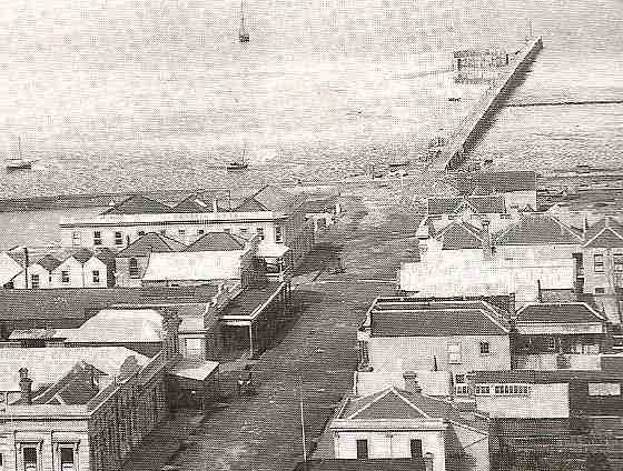
The photograph below was taken from the corner of Pollen and Grey Streets, and shows the challenges of transport at the Thames. Streets were wide, but negotiating them would not have been an easy task!

What were the the transport options on land?
While we have mentioned that the waterways were extremely busy, thousands of residents were also moving around the town and hills above the townships on the Thames Goldfield.

Passenger Tramways:
Steam Train, Grahamstown - Tararu Tramway
The Tararu Wharf was a busy place in the early years of the goldfield; being a deeper water channel it allowed ships an easier port of call for Thames cargo and passengers. To solve the problem of getting people and goods to Grahamstown and Shortland a tramway was built. The Grahamstown and Tararu Tramway Company built a track above the high-water line, the first sod turned May 1869; it was formally opened 2nd December 1871. The tramway ran from “Curtis’ Wharf at the foot of Albert Street in Grahamstown, the line ran north-west to the deep sea wharf at Tararu Point.” It was constructed from iron rails and with a 3ft 6in gauge.

1871 Tararu Foreshore, showing the tramway line from Grahamstown to Tararu.
Carriages could be pulled by steam engine or by horses. Hundreds of people could be transported in any one day. For instance when the large school picnics were held at the Tararu Gardens, up to one thousand would attend, many of whom would travel aboard the tramway and other means of transport on offer.

Horse Transport:
While not many residents were able to own their own horse, there were private companies offering transport via gig and larger carriages. Later stage coaches were used, before the arrival of the first cars in the early 1900s.  In the Thames Star, 13 May 1875 you could even have a private carriage for 6 pence and go from Shortland to Parawai (or reverse) and from Grahamstown to Tararu.


First hand Accounts of Travel at the Thames:

Mrs Macdonald in her booklet Thames Reminiscences shared some memories of getting around Thames in 1867-68. Something we take forgranted today is street lighting, but that was not the case in 1867. Mrs Macdonald wrote "There were no lamps in the streets and everyone carried a lantern at night." She went on to explain what travel was like. "Visiting during those early days was a very difficult matter.  There were no omnibuses or conveyances until later. The houses were scattered, and many of them situated on a high hill. To reach them we had either to go a long way around or up Jacob's ladder, a steep structure of very many steps."

Rev Lush.
The first Anglican Minister at the Thames was Reverend Vicesimus Lush, he knew well the challenges of getting around the goldfield. Getting home from the church to his home above the Hape Creek was hard if it had been raining, let alone the nightmare of getting up to the Shortland Cemetery even further up the hill. In The Thames Journals of Vicesimus Lush, Lush explain that one rainy night down in Rolleston Street he literally had to save a young lady who was stuck in the mud. He dragged the woman to safety but during the rescue procedure "It suddenly flashed across my my mind that I was gradually leaving all the poor wretch's clothes behind in the mud!"    On another occasion, Lush was late catching the steamer to Tapu (also known as Hastings) up the Thames Coast. Lush wrote in his journal "There was now no alternative but to walk - a distance of 15 miles and a very hilly rough road. I was in good walking trim so I tramped on - most of the way slowly in consequence of the steepness of the hills.  It was a lonely walk." Lush went on to recall that he was to share a row boat home, but thankfully got a lift in another boat - no rowing required!

Ellen Fox, wife of Dr Fox, wrote in a letter November 1869 of the challenges travelling around the town of Shortland. Ellen wrote: "There has been plenty of rain and mud...In the street leading to Mrs Mackay's there were cart ruts 3 feet deep - But this is only what one can expect in an unmade street with a very list soil." Mrs Fox went onto write about the trip to Tararu. " The longest ride in a buggy to be got here is to Tararu and back for 2/- about 4 miles - I have been once and intend to go again as it is very pleasant though very rough - one has to hold on tight as the buggy first goes tumbling into the sea and then out again onto great stones." Ellen went onto explain the challenges of the coast road, "they are blasting the rock [from the hill] and throwing it into the sea so that in time they will have a good road." The following year, Dr Fox  bought his wife a small horse to get about on.
Ellen & Dr Alexander Fox
Closing Remarks:
Following the opening of the goldfield in August 1867, Thamesites and visitors to the town found ways to get around the area and travel further afield as required. Nothing was too much of a challenge for these pioneers. For a day out in Auckland they boarded the next available boat. When they wanted a day out to Tararu, they caught the tram or travelled by coach. If all else failed, the majority walked, taking shortcuts as possible, along the beach, up the rivers or up steps such as Jacob's Ladder (that joined lower and upper levels of Grey Street). 
The following decades would see further advancements in travel around the district.

Then & Now - Jacob's Ladder c 1868 & 2015.

Further articles on Transportation:

Saturday, February 9, 2019

Thames (NZ): Transportation - Getting around the Thames pre 1867

Description: View of the harbour and area from Mechanics Bay
to Smales Point. Printed by E Clark and Company (London). 
Sir George Grey Special Collections, Auckland Libraries, 4-623

Introduction:

The following blog, highlights the modes of transport around the River Thames pre 1867. The names of key ships are noted, as they were the prime means of 'getting around' for the settlers and visitors to the shores. The principal destination for settlers was back and forth to Auckland

Tangata Whenua travelled by foot and waka. They also played a vital role guiding the settlers to different districts over tracks they had identified. It was not long before surveyors were employed as the country was colonised, and land ownership became a priority for the new arrivals.

VISITORS & SETTLERS pre 1840
In Caroline Phillips' Waihou Journeys, the archaeology of 400 years of Maori settlements on the lower Waihou River is explored in depth.  It includes an interesting table (page 81) that summarises the European visitors and residents 1769 to 1850. Visitors famous and not so famous who came to the settlements that were scattered along the river. Captain Cook via the Endeavour in 1769; the Fancy 1794, the Hunter 1798 and 1799, the El Plumier and Royal Admiral in 1801 and Samuel Marsden on the Coromandel in 1820. The names of traders, settlers and others are given along with the purpose of their visit and the length of stay.

This 1848 sketch shows a kāinga (village) at Ōpita, Thames. Historically a kāinga would comprise a number of whānau groups. https://teara.govt.nz/en/artwork/30136/kainga

When the Admiral visited in 1801 they spent eight weeks in the Firth of Thames - during this time James Wilson produced a chart of the area. This and other early sketch charts / maps, were the forerunner to more detailed survey maps, that marked tracks and landmarks and in turn greatly aided movement around the district.
Part of Wilson's 1801 Chart of the River Thames - full copy details:
Ref: MapColl-832.15aj/1801/Acc.538. Alexander Turnbull Library, Wellington, New Zealand. /records/22783019

TRAVEL 1840 to 1867
A variety of reports and advertisements in the newspapers provide an insight into the methods of transport and the ease of getting around the greater Thames area.

Boats were sailing around New Zealand with passengers and cargo pre 1850. For instance in November 1849, Mr Nicholas went from the River Thames to Auckland aboard the Alexander. A few of the other early commercial ships mentioned were: the Bon Accord, Charles, Forager, Mary and Piako Lass.

DAILY SOUTHERN CROSS,  21 APRIL 1857
1850s: Land travel was possible over a limited number of 'tracks' but still required forcing through thick bush at times, and was best done with locals as guides. The Plains and River Thames was crossed on a trek from Auckland to Tauranga.

1854: the Gulf of Thames was described as being a commercial world in miniature. On a good day accessible by sea from Auckland by canoe or open boat. The rivers 'The Thames' and 'The Piako' "navigable for barges or steamers for a distance 50 miles at least." NEW ZEALANDER, 27 SEPTEMBER 1854

Local Iwi travelled around the country as required, in 1863 more than 300 Thames Maori were reported to have travelled to Wairoa, during the unsettled years of the 'Land Wars.' By foot and / or by waka, distance was not a problem. During the Land Wars, soldiers also travelled by boat around the Firth of Thames.

So far horses have not been mentioned, but they were around the greater Thames Valley, particularly at the large estates that were owned by men such as Mr McCaskill  (he had settled at Hikutaia in 1839).


Mr MCCASKILL's Estate was being sold with one horse.
DAILY SOUTHERN CROSS, VOLUME XI, ISSUE 756, 26 SEPTEMBER 1854

To conclude, early transport involved walking, use of waka / canoes and private boats; and an increasing numbers of commercial boats. Horses were mainly used on farms, and increasingly in the sport of racing!

Coming next: Transport to / on the Goldfield post 1867.

Background Reading:

Description: A drawing looking south across the Auckland Harbour showing the race of the Maori war canoes during the Auckland Anniversary Regatta of January 1862 with the flagships H M S Miranda left and the H M S Fawn right of centre, taken from 'Views in the Province of Auckland New Zealand' by F R Stack
                  Sir George Grey Special Collections, Auckland Libraries, 863-RB586

Sunday, February 3, 2019

Thames (NZ): Heritage Festival 2019 - Transportation Theme

The Thames Heritage Festival 2019 -  is advertised as running from Friday 15th March to Sunday 17th March 2019, but if you check the website new programmes are being added including for the week leading up to the official heritage weekend.

To follow on from the theme of Transportation on the goldfield the blog will explore travel in the broadest sense, then hopefully tie it back to a new page that will summarise the articles in the series.

TRANSPORTATION at The Thames
Key Points we will be looking at:
  • Local iwi (who settled that land hundreds of years ago) travelled by waka and by foot.
  • Visits by Captain Cook and other early explorers / missionaries
  • The Goldfield invasion and the transport changes they brought
  • Industrial transportation 
  • Infrastructure - wharves, rails and roads
  • Steam to Diesel - the trains should not be forgotten
  • Transport for early Thamesite commuters - shipping and horses
  • Bikes, cars and buses - key events and businesses

View of Thames. ca 1870. Ref: C-030-002. Alexander Turnbull Library, Wellington, New Zealand. http://natlib.govt.nz/records/22470378

BELOW: Mary Street (Queen to Pollen Street) 1900s to 2019.
While the little girl roamed freely along the streets of Thames c1910, the 'traffic' poses no hazards. While the lowest photo shows that even Thames now has a double-decker bus that graces the old goldfield town on a daily basis! Who would have ever guessed. 


HOW DID YOUR ANCESTORS COME TO THE THAMES?
Maybe you can say they came in the Great Fleet c1350AD or more specifically in the Tainui waka that visited Tainui Cove just north of Thames.

Amongst my families who settled on the Thames Goldfield in the opening years, the two that had been in the country the oldest were mother and daughter Susan Timmins (formerly Moran nee McDougal) and Barbarba Cornes (nee Moran) who arrived aboard the Minerva at the end of 1847. This was part of the Fencible scheme. Susan came to the Moanataiari, widowed and destitute when the field opened; while Barbara came with her family and mine manager Clement Cornes.

Ships carried the majority of my early Thamesites to the town. Later in the early 1900s my Grandparents (paternal) travelled from Waihi on a stage coach to settle in the town.

When and how did your Thamesites arrive in the town? Need help answering this question of solving a road block regarding your ancestor's arrival at the Thames - email for suggestions
Showing a coach and horses entering the Main Street at Waihi.
Sir George Grey Special Collections, Auckland Libraries, 7-A8969

Further Research Tips:
Shipping / Passenger lists - PapersPast (lots of lists for earlier years), Archives NZ suggested sites which includes Family Search.

Wednesday, August 15, 2018

Thames (NZ): Shortland Wharf 1891 Painting


Thames River with native canoe in foreground, wooden dwelling in background.Painting by: Cheeseman, Ellen Maud 1848-1928, artist
http://www.aucklandmuseum.com/collection/object/am_library-paintinganddrawings-2398
A magnificent view of Shortland Wharf, the painting by Ellen Maud Cheeseman, signed 1891.
While the Shortland Wharf structure can be clearly seen in the distance, it also shows us how the area was more accessible than today. The landing itself being further east, and vessels such as waka could land well past the Shortland Wharf itself. There few mangroves in those days - or maybe they were cleared! The photo below by W A Price was taken a decade later, in the early 1900s.

PA-Group-00719. Price, William Archer, 1866-1948 :Collection of post card negatives. 1900 - 1930. [Collection]
Repository: Alexander Turnbull Library, Wellington, New Zealand
Who was Ellen Maud CHEESEMAN?
"Ellen Cheeseman was the sister of Thomas Frederick Cheeseman, Curator of Auckland Institute and Museum from 1874-1923." There are several of her watercolours at the Auckland Museum.
Ellen was the daughter of Thomas Cheeseman and Eliza (Cawkwell) Cheeseman

AUCKLAND STAR, VOLUME LVIII, ISSUE 271, 16 NOVEMBER 1927

Friday, November 10, 2017

Thames (NZ): 1930s Thames - a new book

Yet another booklet!!! This time the focus is on the Depression years of the 1930s at Thames.

Title: 1930s THAMES: The Goldfield town revisited

By Althea Barker

An A4 booklet, black and white print, 68 pages, ISBN 978-0-473-41067-4, published Nov 2017.
An overview of the town during the 1930s. Contents include: Businesses, Churches, Depression, Directories (street and telephone), Floods, Hospitals, Hotels, Lost Pioneers, Mining National and world news, occupations, parades, schools, shipping, sports, Trains and transport, and special visits. Plus a section on 'Then and Now' photographs around the town.

BELOW: Book cover front & back for 1930s Thames: The Goldfield town revisited
Thames was used to economic hard times, more so than many other towns around the country. The gold mining booms that mostly never eventuated - to the optimism that the next big 'find' was just around the corner. The town itself was deeply in debt, but businesses and residents alike worked tirelessly to ride out the storm and prepare for better times. Sound embellished? Not at all! Thamesites, as can be seen in the book were well used to supporting one another and meeting the challenges head on. Parades and fundraisers never stopped, despite the usual major flood or two.

Many will have grown up hearing of the hardships of the depression, this booklet looks at Thames during those years.

Wednesday, April 12, 2017

Thames (NZ): View from Upper Albert Street to Wharf

A beautiful view from Upper Albert Street over to the Burke Street Wharf. The postcard was written by Rev E Clyde Grey. Grey was at Hikurangi and New Lynn in the late 1920s to 1930s, his connection to Thames has yet to be confirmed.


The postcard is full of many lost landmarks. At the lower centre of the card is the St Brigid's Catholic Church that was located in Queen Street (between Williamson and Albert Street). The back of the church is on the Pollen Street boundary. (photo right)

Near the foreshore on Beach Road is the Grahamstown Railway Station, that was located opposite the Williamson Street intersect. Taxicabs are lined up, no doubt waiting for passengers off the next train. The Royal Hotel is on the corner of Williamson and Owen Streets. (photo below)
 
Above is the view of Abraham Street on the right beside A & G Price's Foundry, and onto the railway sheds on Beach Road. Then the Burke Street Wharf, awaiting the next lot of boats as the tide permits.
Today the area to the right of the wharf is the Moanataiari Sub-division and full of residential houses.

Saturday, April 8, 2017

Thames (NZ): Methodist Church Choir 1922

Many thanks to Lloyd who keeps finding the most amazing photographs. This time its a photo of the Methodist Church Choir taken 20 October 1922 - the most amazing thing is that it was taken aboard the ps Wakatere. Maybe you recognise someone in the choir?
 
The choir was very successful in competitions around the district. In 1921 the Methodist Choir had won several sections at the Auckland Methodist Choir Festival in Hamilton. There photo was republished in the Thames Star in 1938.

Friday, January 9, 2015

Thames (NZ): Holdships' Wharf at end of Cochrane Street

Yes we had another wharf! The Holdship Wharf belonged to the Holdship Timber Company and they used it for the transport of timber for their timber mill in Bay View (the name given for this area).

Description: Looking from the Holdships Wharf towards Thames, showing houses; Shipping Suppliers store is the two-storied building on Beach Road (left); the Bay View Hotel (centre); St George's Church with spire (right)
Source:  'Sir George Grey Special Collections, Auckland Libraries, 4-RIC136'

 Part of the Mining Illustrated c1868 map below, shows the Holdship wharf at the end of Cochrane Street. On the left at the end of Albert Street, is the Grahamstown Wharf, more commonly known as Curtis' Wharf.
 Source:  'Sir George Grey Special Collections, Auckland Libraries, NZ Map 4531'
 

Thursday, January 8, 2015

Thames (NZ): Then & Now - Curtis' Wharf at Albert Street

Description: THAMES, AUCKLAND, IN THE EARLY DAYS: AN OLD PHOTOGRAPH, SHOWING CURTIS WHARF AND THE WHARF HOTEL WITH THE BANK OF NEW ZEALAND SITE OPPOSITE.
Source: ' Sir George Grey Special Collections, Auckland Libraries, AWNS-19230419-44-1
Curtis' wharf was named after Charles Curtis who was a publican at the Pacific Hotel (c1869 to 1888 at least!), at the corner of Albert and Brown Street. In the c1867 photo above, the Pacific hotel can't be seen to the left of the Wharf Hotel on Albert and Brown Streets. The Grahamstown branch of the Bank of New Zealand had not yet been built (c1871) on the opposite corner. 

A view down Albert Street, showing the wharf and the salt water swimming pool on the left.

 In the Thames Advertiser 9 April 1874, is a typical advert for the Wharf. It was a busy area due to the Grahamstown and Tararu Tramway which left from the area, making it an easy commute for passengers arriving at the Curtis Wharf.
 
The papers in the 1890s report on-going problems with the piles at the wharf and the need for their replacement. Also that the wharf really needed extending or deepening to be of continued use. It must have been normal wear and tear because another report in 1907, when the wharf was being sold, said that the piles were still sound after 30 years.
 
"Mr Wm. Scott (Chairman, of the Thames Harbour Board) stated last night that the piles on which Curtis Wharf had stood for close on thirty years were quite sound. "What is the timber," was asked. "Ti-tree," replied Mr Scott "it is hard to get the big stuff now, but that it lasts has been proved over and 1 over again." (Thames Star, 4 September 1907, Page 2)


Over the years more of the pile structure has been removed, virtually nothing remains today.
Drive down to the end of Albert Street (south of the band rotunda) and remember the hive of activity that once surrounded Curtis' Wharf.