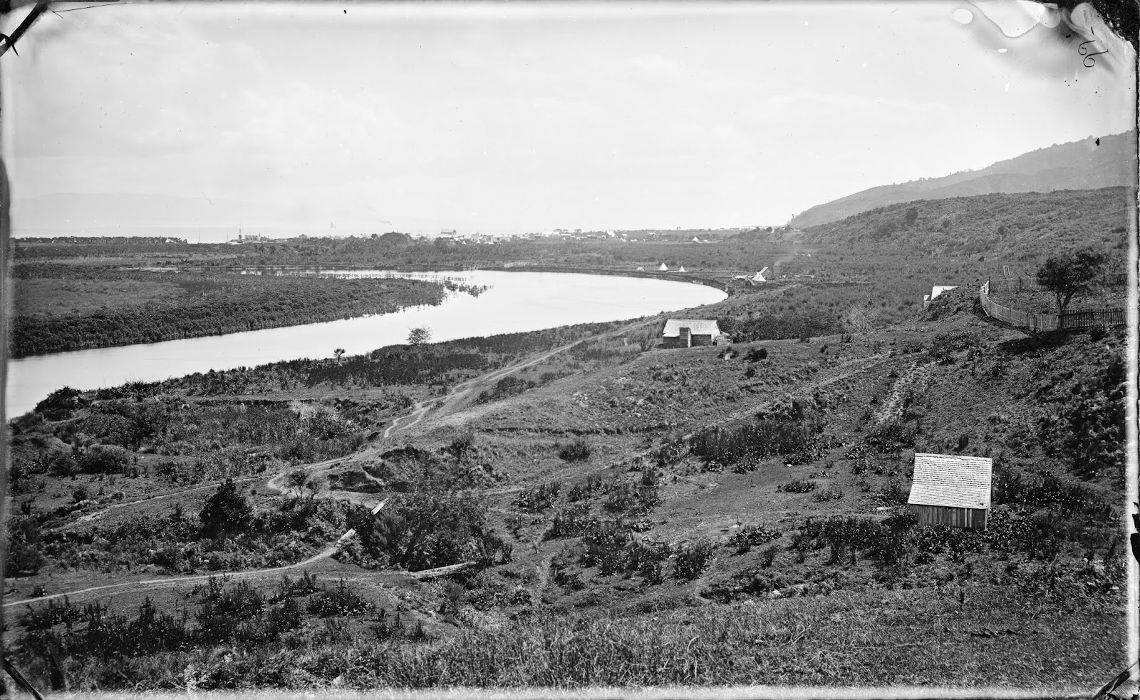
Taken around 1868, the foreground focuses on the area around the Hauraki Mission Station that was located in the Mount Sea Road - Herewaka area of Pārāwai.
Photo Right: View from Hauraki Mission Station at Parawai, towards Shortland. Ref: 1/2-096132-G. Alexander Turnbull Library, Wellington, New Zealand. /records/23172220
Imagine living in this area around 1867, alongside tangata whenua and missionaries. Nestled by the meandering Kauaeranga River, the inhabitants were witness to the development and chaos surrounding Shortland Town and Grahamstown.
A Second Look in Colour
What did you see in the photograph above? A few houses, bush tracks and buildings in the distance?
- Take a 'second look' and spy the Duke of Edinburgh Hotel adjacent to the Shortland Landing - present day this is the area of the Shortland Wharf at the seaward end of Grey Street, Thames. The hotel is the two storied building right of centre in the snip below. There is also a large boat anchored at the landing, with several other masts to the left of centre.

- Moving right in the original D M Beere photograph to the bend in the Kauaeranga River - present day this is the area of Banks Street and Parawai Road. There is a small settlement, with a boat anchored alongside the bank. Abode construction ranges from punga huts, to tents, to small wooden huts, to a large house with an outside chimney billowing smoke. Maybe the residents had been boiling water for wash day, as their long clothes line is loaded with washing!

- The next snip is of a well established area at Pārāwai - the Hauraki Mission Station (HMS) grounds and Church. A well fenced area, with the mission house out of view to the right. The church bell is clearly visible top centre, and on the flat below is the first HMS Church built 1863. The HMS had been established at Puriri in 1833 and moved to Pārāwai in 1837. Present day this is the area around Mount Sea Road and Herewaka Street.

- Given the previous blog post dealt with early footpaths at nearby Shortland and Grahamstown, it would be remiss not to look at walkways and tracks along the Kauaeranga River area. The 'second look' in colour shows the tracks leading from further up the Kauaeranga River back to Pārāwai. The paths look in relatively good condition, although narrow, adequate for foot and horse traffic. Gully areas have what looks like logs, forming footbridges.

Then & Now 1868 & 2019

Photo sources:
Top: Photo Right: View from Hauraki Mission Station at Parawai, towards Shortland. Ref: 1/2-096132-G. Alexander Turnbull Library, Wellington, New Zealand. /records/23172220 Colourised courtesy of MyHeritage.
Lower: Aerial view from Google Maps.
Background Reading:
Hauraki Mission Station (Puriri and Parawai Sites), by David Wilton, Treasury Journal 2008.